[THEORY OF KNOWLEDGE] The Problem With Knowledge
Knowledge is the facts and information that we receive from experience or education. Knowledge makes us know about the world. Knowledge is the key to our survival. But everything in the world is not perfect. Even Knowledge. All of the things we know about the world are not true. SO how do we know what we know?
One example of the problem with knowledge is maps. Maps are used to present how the worlds looks like in a flat surface. The purpose of maps was primarily for navigation. During the Age of Discovery, European cartographers started to create maps for these voyagers. One of the first (and most popular) maps were the Mercator projection map.
The Mercator projection map was made by a European cartographer Gerardus Mercator. It was made in the 1500s for those travellers. This map retains the shape of the landmass but distorts its shape and area of the map as a landmass reaches near the poles of the Earth. This map is not perfect. We can assume that this map was biased towards the Europeans. This assumption was made due to the fact that landmasses such as Europe (which is located near the North Pole) are distorted and enlarged. This gives the impression that European landmasses are large compared to other landmasses of Earth. For example, The Mercator map shows us that Greenland is as big as Africa when in reality it is just 1/14th the size of Africa. This can be caused by imperialism. The Europeans try to claim a huge portion of the world's landmass. The Mercator map projection is one example.
The next map is called the Gall-Peters map projection
Unlike the Mercator map, this map creates equal areal landmasses but sacrifices the shape of the landmass. This map was created in the late 20th century. This map presents us with equal landmasses. For example, Greenland is presented smaller than it is in the Mercator map. This presents us a better understanding of the world. This presents us with the correct way of how the ideal world looks like . Both of these maps are presented north (Europe) up. But what if the north is not the 'North'?
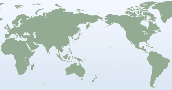
This map is (supposedly) turned upside down. We claim that this map is upside down because it differs from the usual way we look at a map (or what we told the world looks like). This map clarifies that when you're on top you are more powerful than the people of the South (bottom). This thought is what the Europeans try to achieve (and have already achieved) when they attempt to colonialise the whole world. This thought was also relayed in all of the three maps shown above as Europe is shown as the 'centre' of the world. This might be due to the fact that the Prime Meridian line goes through the United Kingdom. But if this map was printed in Asia it would look like this:
Different people view the world differently. Maps represent our knowledge and how we understand the world. So is knowledge represented differently depending on where our knowledge is obtained?
A real life example of this is South Korea. South Korea is trying to change its textbooks because the government thinks that they have interpreted the history in these textbooks wrongly. During the World War 2, Imperialist Japan colonised Korea. They have done bad things to Korea and left behind a huge scar that the Korean nation will never forget. They believe that changing the textbook content will change the way Koreans see the war. But in Japan it can act the opposite way by praising its doings.
To summarise, even things such as knowledge can be flawed because of how people view the world or how people want you to view the world. So do we still know what we know and how do we know the things that we know?


Comments
Post a Comment